The South East Cheshire Cycle Action Group (SECCAG) has produced this map to encourage more people to cycle for everyday purposes in and around the five towns of Alsager, Congleton, Holmes Chapel, Middlewich and Sandbach. The maps are intended for cyclists and potential cyclists to indicate possible routes that might be preferable to using main roads, and to indicate potential hazards and discontinuities in the routes. They should not be taken as indicating the presence of an official route, of cycle-friendly infrastructure or a safe route. Any use that implies otherwise is prohibited.
Cycling in and around Congleton just got easier!
South East Cheshire Cycle Network have got together with Congleton LAP and Congleton Partnership to create a cycling route map of Congleton and the local area. Just click on the links below and enjoy some of the best cycling in Cheshire.
Click here to see a copy of the latest Biddulph Valley Way Cycling and Walking Trail.
Tour of Britain 2016
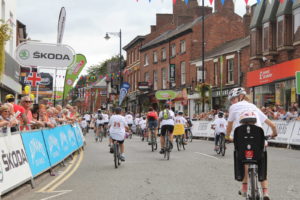
Congleton hosted the start of day three for Britain’s Premier Cycling Event- the Tour of Britain- Tuesday 6th September 2016. It saw some of the worlds best cyclists set off on a 182 kilometre challenging leg around Cheshire East, finishing in Tatton Park. Find out more about when the tour visited Congleton here.
Town Cycling
Linking Map
Click here for PDF copy of the map
Maps produced by Active Maps Ltd., www.activemaps.co.uk.
The maps contain Ordnance Survey data © Crown copyright and database right 2013 & 2022 / © South East Cheshire Cycling Action Group (SECCAG).
Whilst every effort has been made to ensure all the information on these maps is accurate, we cannot guarantee that it is error-free. If you come across any inaccuracies then SECCAG would be grateful if you would let them know. Please contact: enquiries@seccag.org.uk.
In no event will the publishers be liable for any special, direct, indirect or consequential damages out of the use or inability to use these maps.
The representation on the maps of a road, track or path is no evidence of the existence of a right of way.

